
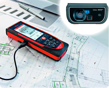
Measure anything from anywhere
Free Anti-Glare Screen Protector with purchase


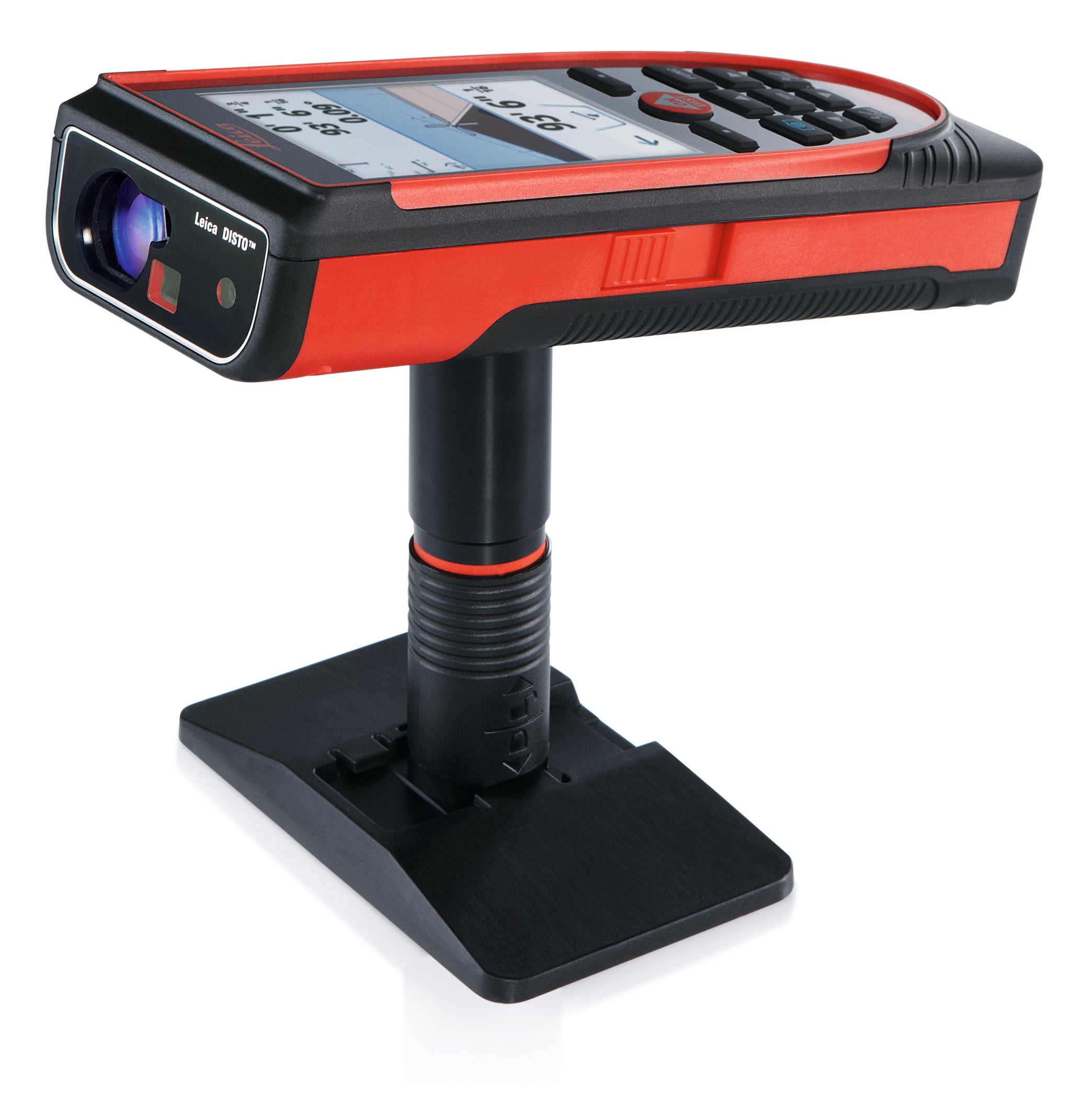
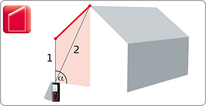
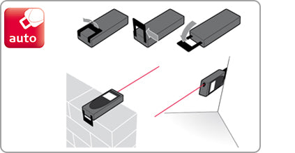
Get to the Point
The Disto S910 uses revolutionary P2P Technology to measure distances between two points, angles and inclinations at the same time from one location. The integrated Smart Base provides both horizontal and vertical angles enabling even the most complex measurement task to be quickly, accurately, and safely carried out.

Disto S910 - S is for Smart

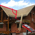
Fold out the Smart Base on the Leica Disto S910 and position the instrument on a stable surface. After targeting and measuring the start and end points of the distance to be measured the required result appears on the display. If the instrument has been levelled, it determines the height difference, the horizontal distance and the inclination of the measured line. Using this function, it is very easy to measure lengths or widths on a roof, for example.

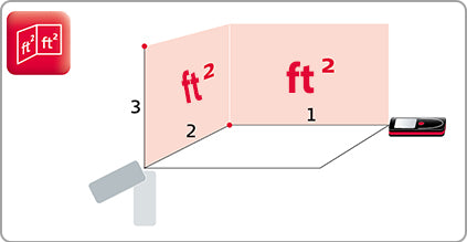
Determine the area and the perimeter of horizontal, vertical and even inclined areas from one point. This is done by positioning the folded out Smart Base on a stable surface and targeting the corner points of the area to be measured, in either a clockwise or anticlockwise direction. Using this method, you can quickly and easily measure complex floor, wall, ceiling or inclined roof areas.
Measure any angle by just measuring three points. No matter how the angle is positioned, by just measuring the points the angle will be calculated and displayed.

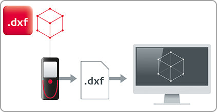
After levelling the Disto S910 with the folded out Smart Base, you can measure points and save them in a DXF file. The files are then available for you to download by USB. The 2D DXF files present floor plans or wall layouts; the 3D DXF files provide you with the measured points in 3D for further processing. As long as the Pointfinder was switched on, you will also be able to download the pictures of the measured points

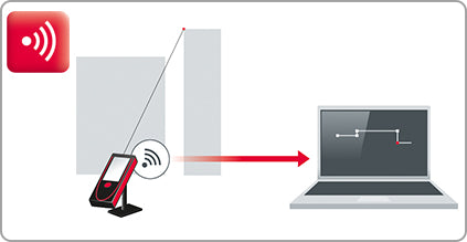
Using the WLAN interface and the Smart Base, you can transfer any number of points in real-time to a portable computer. Leica Disto transfer with Plugin also supports data transfer into AutoCAD and BricsCAD. The data can also be transferred into other third-party software. In these cases, you can make direct use of the full range of functions of your preferred software. This function is ideal for checking existing datasets or preparing new drawings of existing buildings.
A picture is worth a thousand words measurements
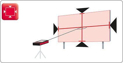
Capture the width, height, area or even the diameter of any object easily with a single measurement. Best results are achieved when the measuring object is displayed maximum size on the S910 screen and measured at a right angle. In such case the accuracy is below 1% of the measured object.
 Measure widths, heights & areas
 You measure at right angles to the object. The object appears in the display and then you can mark the required dimension with the arrows. The display then shows the value. In this way you can, for example, measure the width, height and area of an advertising board using only one distance measurement.
In-Picture Area Video

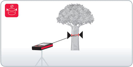
 Diameter measurement
 Measure to the center of the object with the device. The object appears in the display and then you can mark the diameter with the arrows. The display then shows the result. This function is ideal, for example, for determining the diameter of a tree trunk.
In-Picture Diameter Video
Connect and transfer - fast and accurate

Compatible with:
- Apple - iPhone 4s and newer, iPad Mini (all generations), iPad 3 and newer, iPod touch (5th generation and newer)
- Android - Hardware supports Bluetooth 4.0, OS Android 4.3 or higher
- Windows - Hardware supports Bluetooth 4.0, OS Windows 8 or higher
Precision at the core
The Disto S910 offers multiple indirect measuring functions. Due to the specially developed tilt sensor the results are very precise. The digital point-finder and overview camera allow you to target and take measurements in bright sunlight or unfavorable conditions with 1x, 2x and 4x zoom levels.
|
|
|
|
|
|

Throw out your notepad


Replace the classic notepad by drawing sketches and applying measurement results directly to them. Name measurement lines, or draw directly on a photograph. You can also email sketches directly from the job site to the office for further processing.
Disto Sketch App Video
Capture and document with photos
Take pictures for record purposes and download them to your computer using the USB interface. The integrated overview camera gives you more image information. With tricky measurements for example, you can photograph and record target points or specific features.
The screen shot function is excellent for recording information about measurements. You can save all information appearing in the display, i.e. the measurement results and the view of the Point-finder, and then transfer it over the USB interface to a computer. This ensures every measurement is always clearly identified.
Photos are stored in 800x600 resolution, screen shots 240x400 All images are saved in jpg format.

Proven Accuracy and Repeatability
The Disto S910 by Leica Geosystems is compliant to ISO 16331-1, which is a new industry standard developed by an international committee. The range and accuracy of laser distance meters depend greatly on light conditions and how reflective the targeted surface is.
Many distance meters can achieve great results in a controlled laboratory environment, but let's face it, most measuring does not take place in the ideal environment. Leica worked with external experts to help develop and create a standard by which laser distance meters can be tested and compared with each other.
So, what does all of that mean? The Disto S910 will perform to the specifications listed in real life working conditions.

Included with your new Disto S910
Each Disto S910 comes with all the necessary accessories:
- High quality holster with belt loop
- Smart base extension
- Lanyard/hand-loop
- USB charger including 4 plug options
- USB cable
- User Manual and safety instructions on cd-rom
- Calibration certificate silver
- Quick start guide
- Protect Card
- AppraisersLaser.com anti-glare screen protector ($12.99 value)

Learn to use your Disto S910
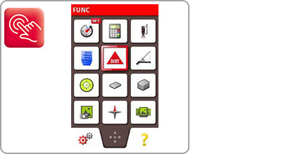
Functions
- ▼
 Minimum/Maximum Measurement
 - In Min/Max mode, you "sweep" the laser point into a corner. The longest measurement is recorded. Very useful for accurate diagonal room or window/door measurements.

- ◄
 Area & Volume Measurement
 - To get the area of a ceiling, floor, wall, or the volume of a room, you only need two or three measurements. No need to write down the individual values! The precise result is calculated automatically and shown on the display.

- ◄
 Digital Point Finder
 - The integrated digital Point-Finder, with a 4x zoom and color display, makes finding the target at long distances a breeze. Its high resolution capability provides a sharp, crystal-clear image, allowing measurements to be taken even in glaring sunshine.
- ◄
 Room Angle / Triangle
 - The triangle function helps you to calculate, quickly and efficiently, the area of a multi-cornered room. Divide the room into imaginary triangles. Using only three measurements, determine the area of each triangle, which you can add up cumulatively. Pressing a key gives you a detailed display of the room angle, so that you can quickly check whether it is a right angle.

- ◄
 Smart Angle
 - Shoot three points to measure any angle. This includes outside angles, which is a first for a laser distance meter.

- ◄
 Painter
 - With this function you can determine the total wall area of a room without having to note down any intermediate results. Simply measure the lengths of the walls which you can add or subtract as required. Finally measure the room height, which is then automatically multiplied by the previously calculated value.
- ◄
 Pythagoras
 - Using the tripod, you can measure distances indirectly, horizontally and vertically.The Leica DISTO calculates the result automatically for you from three measurements. Functions such as automatic minimum and maximum measurements help you to measure the right point.
Partial heights, e.g. balcony or window heights, are determined by Pythagoras.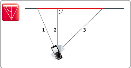
- ◄
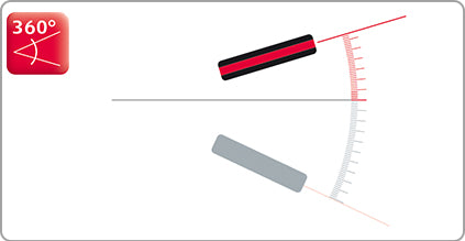
 360° Tilt Sensor
 - The tilt sensors in the Leica DISTO can measure inclinations up to +45°, or even have a measurement range of 360°. This means you can measure inclinations over your head. This is particularly useful for determining roof slopes.
- ◄
 Smart Horizontal Mode
 - The desired horizontal distance is determined using the tilt measurement, event if the object cannot be directly targeted horizontally. This is very helpful if there are obstacles, e.g. walls, hedges or people, between the instrument and the target.

- ◄
 Height Tracking
 - You can determine the heights of buildings or trees that have no suitable reflective points by using the height tracking function. Target with the digital point finder on the bottom point of the height to be measured and take a measurement. Then target with the laser on the top point of the object. The display then shows the height.

- ◄
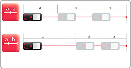
 Stake Out
 - One or two different distances (a and b) can be entered into the device and then used to subtract from defined measured lengths. The display always shows the current stake-out distance and a direction arrow. At a distance of 0.1m to the next stake-out point an acoustic signal sounds.
- ◄
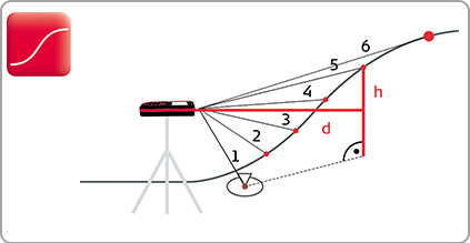
 Height Profile Measurement
 - Target the device on a known reference mark and then measure the height differences of other points relative to this. If the measured points are taken all in one direction the profile of the ground can be determined from the measured horizontal distances and the height differences.
- ◄
 Add and Subtract Measurements
 - It's not always so simple as taking one shot to get the measurement you need. Sometimes its handy to add multiple shots together, or subtract a negative space from a measurement. As you use the Add/Subtract function, the final result is displayed in the main line, and the last measurement taken is shown above.
- ◄
 Camera
 - Take pictures for record purposes and download them to your computer using the USB interface. The integrated overview camera gives you more image information. For example, when dealing with tricky measurements you can photograph and record target points or specific features.
- ◄
 Measure In Picture
 - The dual lens digital camera employs a wide field lens and a 4x zoom lens to power Measure in a Picture (MIP) technology -- the most advanced handheld remote measurement technology currently available. Combined with the data returned by the laser and the tilt sensor, the software uses the fixed focal lengths of the lenses to determine height, width, and area in MIP mode or the circumference and volume in Measure a Cylinder mode. The unit stores images with measurements laid over them for recall on the device or to download later, an especially useful feature for as-built measuring or Building Information Modeling (BIM).
Start by measuring at right angles to the object. After the object appears in the display you can mark the required dimension with the arrows and display the value. With this feature you could, for example, measure the width, height, and area of an advertising board using only one distance measurement.
Diameter measurement Measure to the center of the object with the device. The object appears in the display and then you can mark the diameter with the arrows. The display then shows the result. This function is ideal, for example, for determining the diameter of a tree trunk.
- ◄
 Timer
Timer - Set a timer to delay a measurement the same way you would with the shutter on a digital camera.
- ◄
 Personal Favorite Functions
 - With over 20 functions, chances are you are going to use one or two more than the rest. This Favorites function lets you bookmark your most-used functions on the tabs at the bottom of the touch screen.
- ◄
 Touch Screen
 - The S910 is a touchscreen laser distance measures. In addition to making it easier for you switch between the functions, you can use familiar pinch and expand motions on the touchscreen to zoom the camera in or out. In Measure in Picture mode, you can tap and hold the brackets used to identify the points in the picture that you want to measure.
- ◄
 Compass
 - The Disto S910 is like that big Swiss Army knife you always wanted, the one with all the doodads. The compass is useful for answering questions like, "Wait. Is this the north elevation or the west elevation?" or "Which way am I facing?"
- ◄
 Trapezium
 - The Trapezium Function is useful for determining the length and slope of a roof section, and the area it covers. The DISTO uses the its internal tilt sensor to calculate the angle and the distance between the shots, which means you can measure roofs accurately from the ground.
- ◄
 Sloped Object
 - Indirect distance measuring between two points. The reported measurements also include the horizontal distance between the two points, the vertical distance between the two points, and the angle between the points.
- ◄
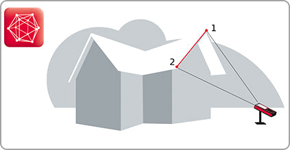
 Point 2 Point
 - Measure the tie distance between two points, even if you are hundreds of feet from your target. Shoot Point 1 then Point 2 and the S910 displays the distance between them. Widths, heights, diagonals, gaps, it doesn't matter: Just measure the start and end point and the distance is displayed.
- ◄
 DXF Data Capture
 - After levelling the Disto S910 with the folded out Smart Base, you can measure points and save them in a DXF file. The files are then available for you to download by USB. The 2D DXF files present floor plans or wall layouts; the 3D DXF files provide you with the measured points in 3D for further processing. As long as the Point-Finder was switched on, you will also be able to download the pictures of the measured points.
- ◄
 Wifi Data Transfer
 - Using the WLAN interface and the Smart Base, you can transfer any number of points in real-time to a portable computer. Leica Disto transfer with Plugin also supports data transfer into AutoCAD and BricsCAD. The data can also be transferred into other third-party software. In these cases, you can make direct use of the full range of functions of your preferred software. This function is ideal for checking existing datasets or preparing new drawings of existing buildings.
- ◄
 Multi-Function End Piece
 - Whether measuring out of corners, slots or from edges, with this end-piece you are prepared for all measuring situations. The instrument detects the end-piece automatically, which helps you avoid expensive measuring errors.


Technical Data
| Measuring Accuracy per ISO | +/- 1mm or ~ 1/16" |
| Range | 1000ft |
| Measuring Units | 0.000m, 0.0000m, 0.00m, 0.00ft, 0'00" 1/32, 0.0in, 0in 1/32 |
| Digital Zoom Levels | 1x, 2x, 4x |
| Overview Camera Resolution | 800x600 pixels, jpg format |
| Screen Shots | 240x400 pixels, jpg format |
| Data Interface | Micro-usb / WLAN / Bluetooth 4.0 |
| File Formats | .jpg / .dxf |
| Smart Base Horizontal Range | 360° |
| Smart Base Vertical Range | -40° to 80° |
| Smart Base Sensor Tolerance | up to +/- 0.1 ° (horizontal/vertical) |
| Leveling Range | +/- 5° |
| Memory | 50 Measurements |
| Protection Class | IP 54 |
| Battery | Lithium-Ion (Built In, Replaceable) |
| Charge Time | 4 hours |
| Measurements per Charge | up to 4000 (reduced in WiFi Mode) |
| Dimensions | 2.4 x 1.3 x 6.5 in |
| Weight with Battery | 10.25oz |
| Country of Manufacture | Austria |
Industry Leading Warranty

Just register your device within eight weeks of the date of purchase and profit from an additional free one year warranty.


Appraiserslaser.com is an authorized Leica dealer. This means we adhere to the strict criteria Leica has when it comes to selling and marketing their products. By purchasing from us, we can assist before and after the sale to insure you have made the correct choice and have the support to back it. You'll get highly-professional support from trained specialists, who'll answer your questions online and offline, before and after you make your purchase.

Sign up to get the latest on sales, new releases and more …
© 2026 AppraisersLaser.com.
A Global Web Supply, LLC Website
Powered by Shopify